
Paul’s Planning Proclamations
Welcome to Paul’s Planning Proclamations, where you will find the latest commentary on matters planning, political or just plain perturbing. Some links on this page may be to external sites not controlled by PSPS. Please advise if a link is broken via the e-mail link at the bottom of the page.
Are Our Waterways Ever Really Protected?
Early one morning about 20 years ago, some Councillors and planners from the then Noosa and Maroochy Councils stood on the southern shores of Lake Weyba and were directed by none other the Goss Government’s first planning minister, the much respected Tom Burns, to prepare a development control plan to guide planning and development in the Lake Weyba catchment. The trigger was the so-called border wars, which erupted when a spy from Noosa dared to visit the planners of Maroochy to inspect a development application over land in the Lake Weyba catchment. I had the pleasure of being that spy.
Minister Burns wanted the squabbling to stop and sought that the Council prepare a definitive document that would identify clearly what should and should not be developed. Now despite the good intentions of the Councils to prepare such a plan, it was never finalised. Did it matter? Well not really, because both Councils used the data from the exercise to inform their respective planning instruments of the time. In Noosa it was its 1997 Strategic Plan (and subsequently the Noosa Plan) and in Maroochy it was Maroochy Plan 2000. Both Councils saw the wisdom in limiting development in the catchment and protecting existing habitat to preserve the significance of Lake Weyba.
Much of the land to the north, east and south of Lake Weyba was transitioned to National Park and more recently, extensive nature refuges have been created to its west. The South East Queensland Regional Plan (SEQRP) was adopted in 2005 and much of the land in the catchment was included in the Regional Landscape & Rural Production Area, which protected it from urban development. The community in and around Lake Weyba settled down, seemingly secure in the knowledge that the values of Lake Weyba and its catchment were protected. But was it?
In 2010, the Sunshine Coast Regional Council was asked to consider a report prepared in response to a Biodiversity Development Offset Area proposal received by the then Department of Infrastructure and Planning. The Council decision was less than enthusiastic, advising in part that:Â The proposed Biodiversity Development Offset Area is not supported as it is likely to lead to a development outcome that does not provide a net benefit to koala conservation values in the area.
But what is this biodiversity offset proposal? Put simply, the developer is seeking that in exchange for protection of areas of koala habitat, he obtains urban development use rights for areas that could otherwise not be used for such purposes. Basically, the developer is attempting to circumvent the provisions of the SEQRP, the Noosa Plan and the Maroochy Plan 2000. What is made all too clear by reading the Council officer’s report is that the areas proposed to be protected by the developer, are already adequately protected under State and Local Government legislation. In other words, the developer is offering the community nothing.
So let’s see what is proposed in these outrageous circumstances. The developer’s concept plan accompanying the Council officer’s report is unreadable, but PSPS has obtained a better copy and this can be accessed by clicking the first plan above. The proposed gross areas on what is indicated as Option 1 on the plan show :

- Town frame 23,68m2;
- Mixed use 13,900m2;
- Hotel with retail tourism edge 24,428m2;
- Community club/recreation facilities 7,718m2;
- Special medium density villas, townhouses with retail tourism edge 25,075m2;
- School 40,619m2;
- Res A, villas, medium density residential, retirement cottages and more retail 1,030,809m2; and
- Let’s not forget jetties and associated buildings in Lake Weyba!
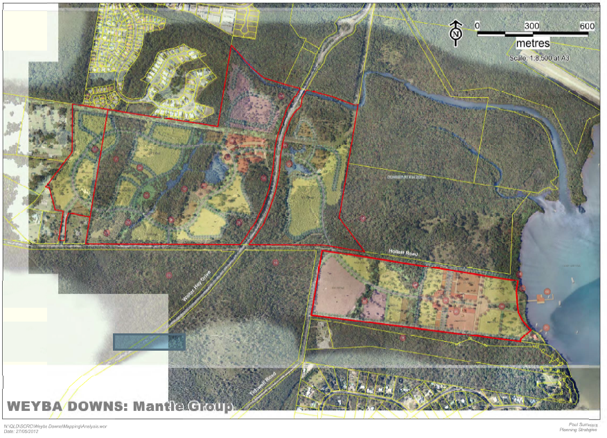
This is nothing short of a whole new town! Now you might have noticed that the developer’s concept plan does not show much of the surrounding area. So PSPS has overlaid the developer’s concept over the aerial photography of the area click the second image above  right.Still not getting the full picture. Click on the third image to the right to access a map which identifies the developer’s property (outlined in red) overlaid over the SEQRP. It lies adjacent to land included in the Urban Footprint, but extends for more than a kilometre to the south. Compare the size of the holding to that of the Noosa Civic, plus the industrial estate plus the adjacent residential estate at Lake Entrance Boulevarde. They are very similar! This is a huge expansion of Noosa’s urban area and it is wholly located in Lake Weyba’s catchment and wholly located outside of the SEQRP’s Urban Footprint. It also radically conflicts with the intended land use under Maroochy Plan 2000 and the Noosa Plan. The great irony is that despite the good planning done in Noosa to protect the area, the water frontage lot of this proposed development site lies in the former Maroochy area and would have to be serviced from the Noosa end were it to proceed!
Not since the Titanium proposal in the Kin Kin area has Noosa had to face a development of this scale and nature. In many ways this one is worse. The coastal area of the former Noosa Shire has not had any significant expansion of its urban area since the limits were put in place in the 1990s. This proposal boldly thrusts southwards, inevitably encouraging further urban expansion in the future.
So are our waterways ever really protected? Like our National Parks they are protected. But as for Lindeman Island and the Bjelke Petersen government in the 1980s, they can still be threatened. This is the case with this shameful development proposal which attempts to exploit the protections afforded this special place by the former Noosa and Maroochy Councils. While nothing apart from the jetties is shown in Lake Weyba, you can bet your winged keel that a marina is one of the options that did not make it on to the plan shown to the Council.
Our waterways are protected, but such protections are only as good as the government that is enforcing them and those governments will respond to a strong community view on the matter. The time to make that view known is now!