The first inhabitants of the Weyba area were the Gubbi Gubbi tribe who were part of the greater Gubbi Gubbi language group. Lake Weyba and it’s catchment area were favoured by the local indigenous tribe for its rich diversity of animal and plant life, and the amenable living conditions.

Lake Weyba must have been a prolific food source in itself for the Gubbi Gubbi tribe, but eugaries were also brought back from the ocean beach in large quantities judging from the shell middens still existing on some of the creek beds around the lake.
The name Weiba (an older spelling) is considered to be derived from an aboriginal word waiam which can mean flying squirrel or stingray. Feathertail gliders can be seen all around the lake gliding from tree to tree in the evenings and, stingrays are prolific in the warm shallow waters.
Early European History
The first Europeans to pass by Lake Weyba would have been escaped convicts from Moreton Bay such as Bracewell and John Graham. The area was first officially explored by William Pettigrew in 1862, and by marine surveyor Heath in 1867. In 1876, E.P. Bedwell of the Royal Navy took soundings of the lake but cattlemen Daniel and Zacharias Skyring had already been running cattle on their 29,000 acre lease, Poreema since 1857, and pastoral activities continued in a non-intensive manner until the 1990’s.
 Early relations between the Gubbi Gubbi tribe and Europeans became acrimonious when, presumably deprived of their hunting areas, the Undanbi began to spear livestock owned by the ever encroaching settlers. The reaction of the settlers was brutal.
One version of the events suggested that an armed party was put together by the Yandina Station manager and a local policeman. They were said to have set up an ambush along the banks of what is still called, Murdering Creek. One of the party waded out into the lake as a decoy and lured nearby Aboriginal fishermen into the line of gunfire.
How many deaths occurred is unknown but in any event, tens of thousands of years of aboriginal occupation was over by the end of the century, about 40 years after Europeans entered the area.
Reminders of Gubbi Gubbi tribal life are still evident today around Lake Weyba in the form of extensive shell middens, scar or canoe trees and even a large stone fish trap in the southern end of the lake.
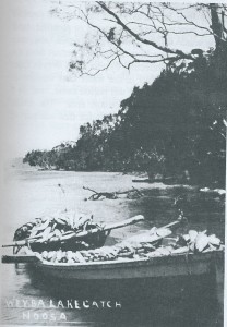
Noosa’s first professional fisherman, Joseph Keyser settled on the northwest shores of Lake Weyba next to the small creek that still bears his name. He is renown for carting his smoked mullet 50 miles over bullock tracks in a wheelbarrow, with his son, Elijah pulling in front with a harness, to sell at the Gympie goldfields.

John Monks settled on Weyba Creek in 1870 and also barrowed his fish to Gympie. He built “The Weyba Homestead†in 1902 which provided board and lodgings and sold home grown vegetables, fish and crabs.
There are rumours that a Chinese market gardener resided on the north west section of the lake in the 1800’s, also barrowing his wares to Gympie. A clump of giant bamboo is now the only evidence remaining today of this local character.
A reserve for Aboriginal Mission purposes was proclaimed by the Queensland Government in 1872. About 4000 hectares in size, it stretched form Sunshine Beach south to Peregian Beach and ran inland past Weyba to Doonan.
The Reverend Fuller set up a mission in the north east corner of Lake Weyba at what is now Noosa Springs. but it closed in 1877, and in 1878 the whole Aboriginal Reserve was cancelled and much of it opened up for European selection at 7 shillings an acre.
In 1893 a commune Woolloongabba Exemplars was set up on the west side of Lake Weyba after the Queensland Government passed the Co-operative Land Settlement Act, offering grants to establish communal kitchens, dining rooms, schools and churches. It flourished for a while reporting that it had an outlet for it’s fish in Gympie and Brisbane and showed good promise for the future. Alas, the shallow hand dug wells soon dried up and the commune appears to have collapsed by early 1896. Some of the timber house stumps were still in evidence around the Eumarella Road area as late as 1980.
The catchment area of the lake was never fertile enough to encourage farming and hence, has remained largely in it’s natural state to this day. All of the eastern shoreline is now national park as is the southwest and northwest corners of the lake.
Recent History
A rural residential community was established in the 1980’s on the old commune site at the lake end of Eumarella Road. The road was named after the Tainsh family property at Rocky Point which was a popular picnic area for Noosa locals through to the 1950’s.
Soon after, another rural residential community was created on the south end of the lake and named Weyba Downs. Noosa Springs then followed on the site of the old Aboriginal mission between Weyba Creek and Noosa National Park. All of these developments are buffered from the lake by well treed zones that have enabled Lake Weyba to retain much the same appearance as it would have in the times of it’s Gubbi Gubbi protectors.
There will always be pressure to further develop the area and strong ongoing planning around the shoreline will be necessary to preserve this ancient vista far into the future.
Bill Tainsh
Reference Resources – Nancy Cato, Stan Tutt, Colin Monks
